2023 Winter Storm/Atmospheric River
Emergency Storm Update – 1/11/23 at 7:50 PM
URGENT NOTICE
Severe flooding of the Salinas River may cut off the Monterey Peninsula starting at noon on January 12th. Stay up to date – visit Monterey County 2023 Winter Storm Page HERE.
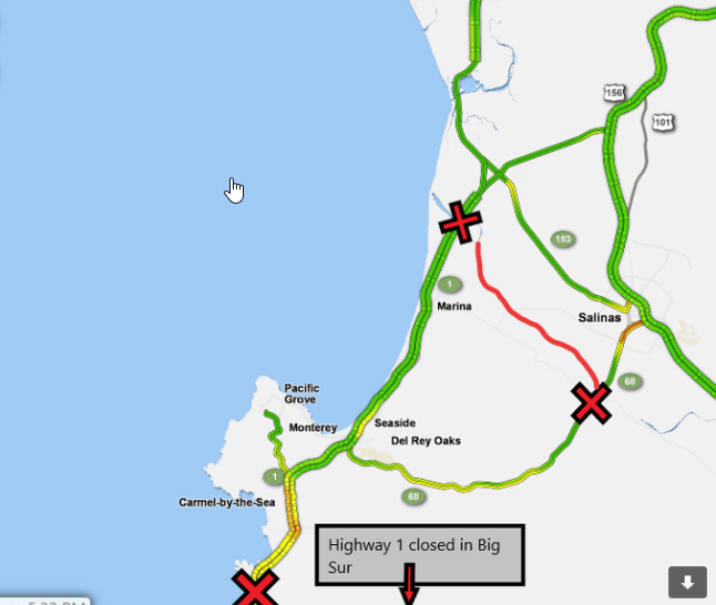
There is a high probability that the Salinas River will flood ALL access points into the Monterey Peninsula at some point on Thursday, Jan. 12th lasting through Sunday. (see map above) The Salinas River is expected to reach flood stage as early as noon Thursday, at Highway 68 at Spreckles, and Highway 1 north of Marina. Based on National Weather Service and the Monterey County Water Resources Agency models, State and local officials are preparing for continued flood stage through 9:00 p.m. Sunday, January 15.
All residents and workers are urged to plan ahead. Anyone who is on the peninsula when flooding occurs will not be able to leave. Anyone who is not on the peninsula will not be able to enter. Floodwaters could remain on the roads for up to three days with clean-up and repair requiring work before roads can reopen.
The flooding concerns on the roadways will likely impact the approaches to the bridges, low lying intersections, and local surface streets. Roads near the Salinas River that are expected to flood include State Route 68, River Road, Reservation Road, Blanco Road, multiple secondary roads, and potentially US 1. Everyone is urged to stay off the roads and postpone travel.
Please continue to watch local news, and the County Storm Tracker for the latest updates, and continue to stay safe.
- Sign up for ‘Nixle’ local emergency alerts on your mobile phone HERE
- Click HERE for County Evacuation Map
SAFETY REMINDERS
For non-emergencies, please contact Police Dispatch at: 831-624-6403
For EMERGENCIES, including downed power lines or if you smell gas, dial 9-1-1
Some helpful safety tips:
- Please respect closures, and stay clear from areas with police tape, flares, barricades, etc.
- Flood waters move FAST, please stay away
- If you see downed lines (any lines), DO NOT TOUCH and STAY AWAY
HOTELS OFFER DISCOUNTS FOR EVACUEES
The weather forecast is for heavy-at-times showers for several
more hours with rain ending over the Monterey Peninsula by
mid-afternoon, at least until early tomorrow morning.
But rivers are still rising and evacuation orders remain in
effect for portions of the Carmel, Big Sur and Pajaro Rivers,
along with Arroyo Seco.
To help people who have to leave their homes find a place to
stay, hotels in Carmel and other parts of the county are offering
discounts for evacuees.
The Carmel Chamber of Commerce has a list
of available rooms and rates in Carmel. And the Monterey
Convention and Visitors Bureau has a list that
includes other
parts of the county.
A private medical transportation company says it is available to
assist with wheelchair and gurney evacuations.
Click here for
more information.
Current Situation – 1/9/23 10:30 am
Two significant storms have passed through Monterey County, with the most powerful system currently occurring Monday and Tuesday. The current storm has the potential for widespread and multiple impacts due to moderate to heavy rain, flooding, and strong winds, which could threaten lives.
Key Points:
- Threat to life is likely during these storms.
- Soils remain saturated, which means a high risk of flooding
and shallow mud slides.
- Expect rapid rises in creeks and streams as well as rises in
main stem rivers.
- Periods of strong winds with gusts 40 to 60 mph (potentially higher in the mountains) could lead to downed trees/power outages.
Evacuation Order issued for areas of the Carmel River 1/9/23 Effective Immediately
2023-01-09 07:00:18 PST
The Monterey County Sheriff’s Office has issued an Evacuation Order for low-lying areas of the Carmel River effective immediately and until further notice due to the incoming storm. If you are in an Evacuation Order Zone quickly and calmly evacuate. Check with your neighbors to ensure they have been made aware of this alert.
- If you have large animals or need extra time to evacuate, now is the time to do so. Monitor local media, social media, and Nixle alerts for updates. Call 2-1-1 for information. Call 9-1-1 only if you have a life-threatening emergency.
- If you need animal sheltering, call the SPCA at 831-373-2631. For the SPCA after hours line call 831-646-5534
- An Emergency Shelter is available for residents in the Monterey Room at Monterey County Fairgrounds located at 2004 Fairground Rd, Monterey, CA.
- A Temporary Evacuation Point is located at the Carmel Valley Library from 8am-5pm.
- To view an Evacuation Map: https://bit.ly/3Za0Xc0
Alerts, Warnings, and Orders
Weather Alerts
The National Weather Service has issued flood watches and warnings for Monterey County. Remember a Watch means flooding may occur, while a Warning means flooding is occurring or is imminent .
- Flood Watch for Monterey County from 1/8/2023 at 11:30pm until 1/9/2023 at 4:00pm PST
- Flood Warning For Carmel River at Robles del Rio
- Flood Warning for Salinas River near Spreckels
Carmel-by-the-Sea Update 1/5/2023
- Approx. 30 trees down around the city
- Some structures damaged
- Sign up for ‘Nixle’ emergency alerts on your mobile phone HERE
- Multiple street closures around the Village
- High water levels in Carmel River and Lagoon, continuing to rise.
EVACUATION ORDERS – Mission Fields Area (south of 15th Ave, and east of Carmelo St.)
EVACUATION WARNINGS – Carmel Lagoon Surrounding Areas (south of Santa Lucia Ave, and east of San Antonio Ave.)
Click HERE for County Evacuation Map
- Highway 1 temporarily closed just south of Rio Rd.
- More rain coming in the next week
- National Weather Service Forecast for Carmel-by-the-Sea - Click here
For non-emergencies, please contact Police Dispatch at: 831-624-6403
For EMERGENCIES, including downed power lines or if you smell gas, dial 9-1-1
Some helpful safety tips:
- Please respect closures, and stay clear from areas with police tape, flares, barricades, etc.
- Flood waters move FAST, please stay away
- If you see downed lines (any lines), DO NOT TOUCH and STAY AWAY
-
Power could still potentially be out for extended periods over the next week, plan accordingly
01/05/2023 9:33 AM: The Monterey County Sheriff’s Office has issued an Evacuation Warning for areas of the Fourth Addition Neighborhood and Carmel Point effective immediately and until further notice. This includes areas:
-
East of Valley View Avenue
-
South of Santa Lucia Ave
-
West of Rio Rd
-
North of Dolores St/ 14th Ave/17th Ave
If you are in an Evacuation Warning Zone prepare to leave. Be ready to leave if an evacuation order is issued. Gather essential items now to be ready to go. If you feel unsafe, do not wait for an evacuation order, leave immediately. Check with your neighbors to ensure they have been made aware of this alert.
01/05/2023 9:23 AM: Avoid Coastal areas of Monterey County due to high surf and high wind conditions due to the storm. Evite las zonas de la costa del condado de Monterey debido a fuertes oleajes y condiciones de viento por la torment
01/05/2023 08:42 AM : The Monterey County Sheriff’s Office has issued an Evacuation Order for residents near the Carmel River Lagoon effective immediately until further notice. This includes areas south of 14th Ave and East of Carmelo.
Temporary Evacuation Points
Temporary Evacuation Points will be open Wednesday 1/4 to Friday 1/6 from 8:00 AM to 5:00 PM at the following locations:
- Carmel Valley Library located at 65 W Carmel Valley Rd, Carmel Valley, CA 93924
- Prunedale Library located at 17822 Moro Rd, Prunedale, CA 93907
- King City Library located at 402 Broadway St, King City, CA 93930
Emergency Shelters
- Cesar Chavez Middle School at 440 Arthur Rd, Watsonville, CA 95076 open starting Wednesday January 4, 2023.
- Sherwood Hall in at 940 N Main St, Salinas, CA 93906 is on standby if needed. Call 2-1-1 if you need shelter.
- If you need animal sheltering, call the SPCA at 831-373-2631, after hours call 831-646-5534
Carmel Hotels
- Certain Carmel hotels are offering special discounts to storm evacuees. Checkout the Visit Carmel website and look for the Storm Evacuee Hotel Offers at the top of the page.
Information
- Flood Safety Information
- Winter Storm Preparedness Information
- Monitor Stream Gauges
- Sandbag Distribution List
- Sand Stockpiles
- PGE Outage information can be found HERE
- Road Closure information is available from Monterey County Public Works
- Call 2-1-1 for information
Storm system expected week of January 2, 2023
WHAT IS THE CITY DOING TO PREPARE?
The Farmers’ Market will be canceled for Thursday, January 5 in anticipation of the storm.
The City of Carmel-by-the-Sea Public Works, along with Carmel Police and Fire, are working around the clock to prepare for the storms, minimize disruptions, and keep people safe. The City has staffed additional Police, Fire, and Public Works staff during the storm, as well as our CERT Team and partnership with Monterey Fire. The City also has on-call tree services for assistance with downed trees. Sandbags are available at Vista Lobos Center, located at Junipero and 3rd.
The City of Carmel-by-the-Sea will activate the Emergency Operations Center (EOC) if necessary, which is a secure facility where departments can work closely together to coordinate the emergency response, allocate resources, and support management of the incident. City staff conducts regular training drills to prepare for various emergencies, including storms.
CONTACT US
- Call 9-1-1 for Police/Fire/Medical emergencies
- Carmel Police Department (non-emergency) – 831-624-6403
- Carmel Fire Department – 831-620-2030
- Public Works – 831-620-2070 – email
- City Forester – 831-620-2073 - email
DURING AND BEFORE THE STORM
- Message from Monterey County regarding storm preparedness - In part, The County, in concert with the National Weather Service, will be issuing multiple advisories and alerts to help residents prepare and stay safe during this weather event. Should these alerts include the need for evacuations, county emergency agencies are creating contingencies for evacuation shelters should they be needed. Read full message from the County of Monterey on Storm Preparations
- Flood Watch In Effect Late Tues., 1/3 through Thu afternoon, 1/5 – Sign up for Alert Monterey County to receive these messages directly.
- Sandbag Distribution List – Monterey County
- Sandbags are available at Vista Lobos Center – (note: sand and bags are available but you must fill yourself)
- Monterey County Road Conditions and Closures
- PG&E Electric Outage Center & Storm Safety – including outage map, contact info, outage preparedness and more
- Monterey County Winter Storm Preparedness Website
POWER OUTAGES
- Have battery-operated flashlights and radios with fresh batteries ready. Listen for updates on storm conditions and power outages.
- If you have a telephone system that requires electricity to work (such as a cordless phone or answering machine), plan for alternate communication – have a standard telephone handset, cell phone ready as a backup.
- If the situation creates a power outage, please tune your radio to: Radio 1610 AM – Your Information Station. The recorded message is updated regularly during emergency situations.
STORMY WEATHER SAFETY TIPS
- Treat all downed power lines as if they are “live” or energized. Keep yourself and others away from them. Call 911, then notify PG&E at (800) 743-5000.
- Avoid flooded locations and areas with downed trees. Both are typical places for downed lines to occur. Remember, call 9-1-1 first to report downed lines.
- Use battery-operated flashlights, or LED candles (not wax candles).
- Customers with generators should make sure they are properly installed by a licensed electrician. Improperly installed generators pose a significant danger to our crews.
- Unplug or turn off all electric appliances to avoid overloading circuits and fire hazards when power is restored. Simply leave a single lamp on to alert you when power returns. Turn your appliances back on one at a time when conditions return to normal.
CHECKING UTILITIES
- Check for gas leaks. If you smell gas or hear blowing or hissing noise, open a window and quickly leave the building. Turn off the gas at the outside main valve if you can and call the gas company from a neighbor’s home. If you turn off the gas for any reason, it must be turned back on by a professional.
- If you see sparks or broken or frayed wires, or if you smell hot insulation, turn off the electricity at the main fuse box or circuit breaker. If you have to step in water to get to the fuse box or circuit breaker, call an electrician first for advice.
- If you suspect sewage lines are damaged, avoid using the toilets and call a plumber. If water pipes are damaged, contact the water company and avoid using water from the tap. You can obtain safe water by melting ice cubes.